Tuesday, December 30, 2008

Timbuktu


Timbuktu is widely used to describe a place extremely far away and regarded by many as a myth. In reality it's a city in Mali, West Africa, of such great historical importance that in 1988 it was designated a World Heritage Site.Situated on the southernmost edge of the Sahara Desert, Timbuktu is about eight miles from the Niger River -- closer during the rainy season. It was founded in the twelfth century by Tuareg nomads. By the fourteenth century it had became a major center for the trans-Sahara gold and salt trade as well Islamic scholarship and culture, the Oxford University of the Sahara, despite the rise and fall of powerful dynasties around it.When the emperor Mansa Musa undertook an extravagant pilgrimage with an entourage of thousands from Timbuktu to Mecca via Cairo in 1324, he transformed European and Arabian perceptions about West Africa. Stopping in Cairo to visit the sultan, Musa gave away so much gold that the Egyptian money market crashed.Musa built the Great Mosque (Djinguereber) and commissioned the Granada architect Abu Ishaq asSahil to design the Sankore mosque. The Sankore University was established around the mosque. The Great Mosque has been rebuilt many times, but the Sankore mosque still stands, probably because it was built around a wooden framework which aids the repairs necessary after the annual rains.By the 1450s, the population reached some 100,000, a quarter of these were scholars, many of whom had studied in Egypt or Mecca. The city reached its peak during the Askia period (1403-1591). Merchants from North Africa came to trade salt, cloth and horses for gold and slaves. Leo Africanus, a Muslim from Granada, left a account of his visit in 1526, which renewed European interest in the "city of gold".In 1591 Morocco captured Timbuktu. In 1593 its scholars were arrested on suspicion of disloyalty, some were killed and others exiled to Morocco. Even more devastating was the inability of the Moroccan troops in control of the city to protect it from repeated attacks by the Bambara, Fulani, and Tuareg. Timbuktu was in decline.European explorers were still attempting to reach Africa's 'city of gold' but none had survived. In 1788 a group of Englishmen formed the Association for Promoting the Discovery of the Interior Parts of Africa, primarily to discover the source of the Niger and reach Timbuktu. The race was on.Most famous of the failures was Mungo Park. Robbed, tortured by warlords, and finally drowned when his raft was attacked, he did at least get to the Niger, "glittering to the morning sun, as broad as the Thames at Westminster."In 1824 the Geographical Society of Paris offered a considerable reward for the first European to visit Timbuktu and return to tell their tale. The Scottish explorer Gordon Laing is acknowledged as the first European to reach Timbuktu, in 1826. He'd survived a savage attack by Tuareg nomads on his journey from Tripoli to Timbuktu, but was murdered two days after leaving the city.

It was only in 1828 that the first European who lived to tell the tale reached Timbuktu. The French explorer, RenƩ-Auguste CailliƩ disguised himself as an Arab -- he had studied Islam and could speak Arabic. His journey from the coast of West Africa to Timbuktu took him a year (he was ill for five months) but he was so unimpressed he spent only two weeks in the city. His three volumes of his adventures were published in 1830 and received the Geographical Society of Paris' prize.

Other explorers, such as the German geographer Heinrich Barth who visited the city during his five-year trek across Africa, also found the city an anticlimax. A city of mud-walled buildings in the middle of a harsh desert, not a city of gold. (View some illustration from his book Travels and Discoveries in North and Central Africa.)

Timbuktu was captured by the French in 1894 who partly restored the city; in 1960 it became part of the independent Republic of Mali. Today Timbuktu is still on the "must-do" list of adventurous travellers, but few have any idea why such a desolate city should be. With the restoration efforts started in the late 1990s to reclaim some of Timbuktu's heritage from the sands of the Sahara, there is hope that this can change.

Monday, December 29, 2008

Yellowstone National Park


Yellowstone National Park is locate in Northwest corner of the State of Wyoming and relatively small adjacent areas of the States of Montana and Idaho -

N 44 27 38 W 110 49 40

It covers 898349 ha.
The vast natural forest of Yellowstone National Park covers nearly 9,000 km2; 96% of the park lies in Wyoming, 3% in Montana and 1% in Idaho. Yellowstone contains half of all the world's known geothermal features, with more than 10,000 examples. It also has the world's largest concentration of geysers (more than 300 geyers, or two thirds of all those on the planet). Established in 1872, Yellowstone is equally known for its wildlife, such as grizzly bears, wolves, bison and wapitis.

Yellowstone's Ancient Supervolcano

The geysers of Yellowstone National Park owe their existence to the "Yellowstone hotspot"--a region of molten rock buried deep beneath Yellowstone, geologists have found.
But how hot is this "hotspot," and what's causing it?
In an effort to find out, Derek Schutt of Colorado State University and Ken Dueker of the University of Wyoming took the hotspot's temperature.
The scientists published results of their research, funded by the National Science Foundation (NSF)'s division of earth sciences, in the August, 2008, issue of the journal Geology.
"Yellowstone is located atop of one of the few large volcanic hotspots on Earth," said Schutt. "But though the hot material is a volcanic plume, it's cooler than others of its kind, such as one in Hawaii."
When a supervolcano last erupted at this spot more than 600,000 years ago, its plume covered half of today's United States with volcanic ash. Details of the cause of the Yellowstone supervolcano's periodic eruptions through history are still unknown.
Thanks to new seismometers in the Yellowstone area, however, scientists are obtaining new data on the hotspot.
Past research found that in rocks far beneath southern Idaho and northwestern Wyoming, seismic energy from distant earthquakes slows down considerably.
Using the recently deployed seismometers, Schutt and Dueker modeled the effects of temperature and other processes that affect the speed at which seismic energy travels. They then used these models to make an estimate of the Yellowstone hotspot's temperature.
They found that the hotspot is "only" 50 to 200 degrees Celsius hotter than its surroundings.
"Although Yellowstone sits above a plume of hot material coming up from deep with the Earth, it's a remarkably 'lukewarm' plume," said Schutt, comparing Yellowstone to other plumes.
Although the Yellowstone volcano's continued existence is likely due to the upwelling of this hot plume, the plume may have become disconnected from its heat source in Earth's core.
"Disconnected, however, does not mean extinct," said Schutt. "It would be a mistake to write off Yellowstone as a 'dead' volcano. A hot plume, even a slightly cooler one, is still hot."

-Yellowstone recently Earthquakes

From 1,000 to 3,000 earthquakes typically occur each year within Yellowstone National Park and its immediate surroundings. Although most are too small to be felt, these quakes reflect the active nature of the Yellowstone region, one of the most seismically active areas in the United States. Each year, several quakes of magnitude 3 to 4 are felt by people in the park.

Although some quakes are caused by rising magma and hot-ground-water movement, many emanate from regional faults related to crustal stretching and mountain building. For example, major faults along the Teton, Madison, and Gallatin Ranges pass through the park and likely existed long before the beginning of volcanism there. Movements along many of these faults are capable of producing significant earthquakes. The most notable earthquake in Yellowstone’s recent history occurred in 1959. Centered near Hebgen Lake, just west of the park, it had a magnitude of 7.5. This quake caused $11 million in damage (equivalent to $70 million in 2005 dollars) and killed 28 people, most of them in a landslide that was triggered by the quake.
Geologists conclude that large earthquakes like the Hebgen Lake event are unlikely within the Yellowstone Caldera itself, because subsurface temperatures there are high, weakening the bedrock and making it less able to rupture. However, quakes within the caldera can be as large as magnitude 6.5. A quake of about this size that occurred in 1975 near Norris Geyser Basin was felt throughout the region.

Even distant earthquakes can affect Yellowstone. In November 2002, the magnitude 7.9 Denali Fault earthquake struck central Alaska, 1,250 miles (2,000 km) northwest of Yellowstone. Because this quake’s energy was focused toward the active Yellowstone volcanic and hydrothermal system, it triggered hundreds of small earthquakes there. The region’s hydrothermal system is highly sensitive to quakes and undergoes significant changes in their wake. Earthquakes may have the potential to cause Yellowstone’s hot-water system to destabilize and produce explosive hydrothermal eruptions.
During the month of February 2005, 61 earthquakes were located in the Yellowstone region. The largest of these shocks was a magnitude 2.8 on February 22, 2005 at 6:49 PM MST, located about 9.1 miles north northwest of Madison Junction, Wyoming. No earthquakes in this period were reportedly felt.

Earthquake activity in the Yellowstone region is at relatively low background levels.

source 1 2 3

Saturday, December 27, 2008

Kiyomizu Temple, Kyoto, Japan


"Enchin, a priest from Nara, was told in a vision to "Look for the clear water origin of the Yodo river" In a long search, he stumbled upon a place deep in the forest greenery where a mist, like a belt of white clouds, hung over a waterfall at the foot of Mt. Otowa."
This famous temple received World Cultural Heritage Listing by UNESCO in December 1994. Kiyomizudera (The Clear Water Temple) is the main temple of the Hosso sect of Buddhism and has been destroyed and rebuilt many times in its twelve centuries of history. The Shinto Jishu Shrine is located here also. Kiyomizudera is said to have been constructed from 778 by Enchin, a buddhist priest, in honor of the Kannon Bosatsu (Bodhisattva of Mercy and Compassion). A bodhisattva is one who can achieve enlightenment but decides to remain on earth to assist others in achieving nirvana.
According to the legend, Enchin received a vision that said he would find at the source of the Yodo river, a clear source of water. During his search Enchin came across a hermit named Gyoei. Gyoei was a old priest practising ascetism and he gave Enchin a piece of wood possessed by the spirit of the Kannon Bosatsu. This was then carved into the likeness of the Kannon and Enchin then enshired the image in a small thatched roofed hut. This was the begining of Kiyomizudera. The legend also says that the hermit disappeared, and that when Enchin later found the hermit's sandals on top of the mountain, he realized that he had actually been speaking with a manifestation of the Kannon. On the other hand, the hermit may just have wanted some peace and quiet.
The legend continues that Sakanoue Tamuramaro, one of the emperor's leading generals came upon Enchin while deer hunting. The blood of a stag was thought to ease the pain the childbirth, and Tamuramarro's wife was about to give birth. Enchin spoke of the cruelty of killing animals (forbidden in the Buddhist tradition) and his speech so moved Tamuramaro that to repent, Tamuramaro underwrote the construction of a proper sanctuary. (Another story is that he disassembled his home and gave it to the temple, building a new house to replace it).
In 794 the emperor Kammu moved his capital to Kyoto and gave Tamuramaro his throne hall as a reward for his military service. As a devout worshipper of Kannon he proceeded to donate the building to Enchin for a new main hall. The building stood until 1629 until it was destroyed by fire. Today's Main Hall has roof made of cypress, not the traditional tile, in remembrance of originally being part of the emperor's palace. Most of the buildings today were rebuilt by Iemitsu Tokugawa, the 3rd shogun of the Tokugawa Shogunate, in 1633.

To get to the temple, you first make your way up Ninnen-zaka & Sannen-zaka walk, past the Omiyage shops until you reach the main gate of Kiyomizudera. The first thing you will see on the left is the old horse stables used by those going to offer their prayers to Kannon. Walking from there into the temple you will walk under the Nio-mon or Gate of the Deva Kings. The Deva Kings, along with Korean lion-dogs (koma-inu) protect the temple from any evil that may enter. The right Deva King has his mouth open, pronouncing "A", the first sound of Sanskrit while the other has his mouth closed, pronouncing "UN", the last sound. Thus, it is thought that the Deva Kings represent the complete teachings of Buddha.
Continuing past the Nio-mon, you go up a second flight of steps to the Sai-mon (West Gate). Two more Deva Kings stand guard at this eight pillared gate built in the early 17th century. To the gate's left one can see the Shoro (Bell Tower) built in 1596, though the temple's bell was cast in 1478. Above the flying brace of the tower one can see the imperial Chrysantheum crest.
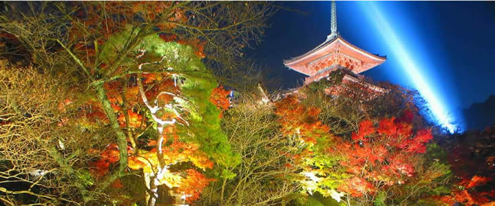
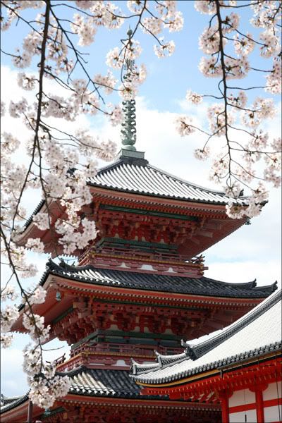
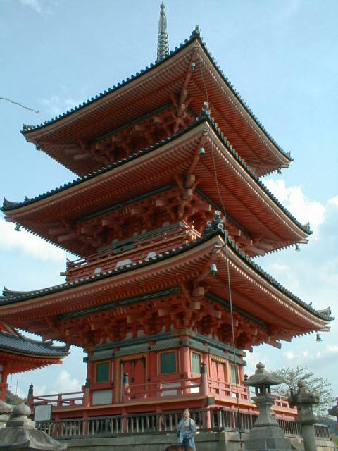
Behind Sai-mon rises Sanju-no-to (Three Storied Pagaoda), the tallest three-storied pagoda in Japan. Rebuilt in 1633 and repainted in 1987 in the original vermilion, the pagoda stands out against the dull brown of the other buildings. The bright color is typical of Buddhist temples, reflecting the Chinese architectural styles that came to Japan together with Buddhism.
After the pagoda is the Kyodo (sutra hall). This is where the sacred scriptures are kept. The hall contains images of the Buddhist deities of virtue (Monju) and wisdom (Fugen), along with a ceiling painting of a coiled dragon. On the right of the Kyodo is Zuigu-do or Jishin-in (Temple of Mercy) which was rebuilt in 1728. This was the favorite place of worship for Toyotomi Hideyoshi, and the temple still has some of his belongings.
Kanisan-do (Founder's Hall) comes next in line. It is also called the Tamura-do, to honor Tamuramaro. The hall was moved from Nagaoka to Kiyomizudera in the late 8th century and holds images of Gyoei the hermit, Enchin the priest, Tamuramaro and his wife, Takako.
Walking to the right of Kanisan-do will bring you upon Todoroki-mon. The middle gate contains yet another pair of Deva Kings, who protect the inner temple. This gate is called the "gate resounding to the call of the Buddha's teachings". In front of the gate is a hand washing trough with a dragon shaped water pipe. On the base of the trough is an owl design, which explains why the water from the dragon's mouth is often call "Owl Water".
Ahead of Todoroki-mon and to the left is Asakura-do. The hall was presented in 1633 by Akakura Sadakaga (1473-1512), son of the emperor Temmu and holds an Eleven-faced Kannon flanked by images of Bishamon-ten (god of wealth) and Jizo (guardian of children). On the side of the hall is a set of footprints of the Buddha. (In the early years of Buddhism images were not created of Buddha or the bodhisattvas therefore it was thought the footprints were a sufficient reminder of Buddha's way.) It is said that if one looks at the prints all their sins are forgiven. Have a closer look at the prints and you will see several symbols including a pair of fish, a floral crest, and a conch shell. If you look at the heel, a faint impression of the Buddhist Wheel of True Law can be seen. To the left of this building a small pond containing a small island can be seen. The island is called Benten-jima and is named after the Shinto goddess Benten whose shrine rests on the island.
Directly past these structures you come to the main attraction of Kiyomizudera, the Hondo or Main Hall. Though the original structure, donated by Tamuramaro, was destroyed by fire in 1629 the present building is true to the Heian period style of architecture. Inside, the outer sanctuary is quite simple, decorated with 30 paintings donated by tradesmen during the 1633 rebuilding of the temple. The inner sanctuary is startlingly different. Many gold leaf images are displayed on raised black laquered platforms behind vermilion railings. Echin's image of Kannon is kept in a case with the 28 followers of Kannon by its side. On the corners of the platform the case rests on stand four Deva Kings, protecting all of the images. In the east of the hall is an image of Bishamon-ten and the west houses an image of Jizo. These two images, along with the Kannon image, are also said to have been carved by Enchin. If you are hoping to catch a glance at the Eleven-faced thousand-armed image you will have to wait until 2010. The image is only shown once every thirty three years (one year for every vow Kannon took to save mankind) and the last showing was in 1977. Fear not, pictures of Kannon, Jizo, and Bishamon are hung above the cases at all times.
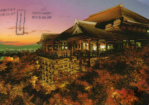
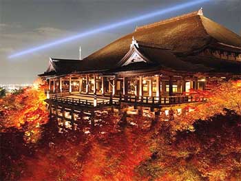
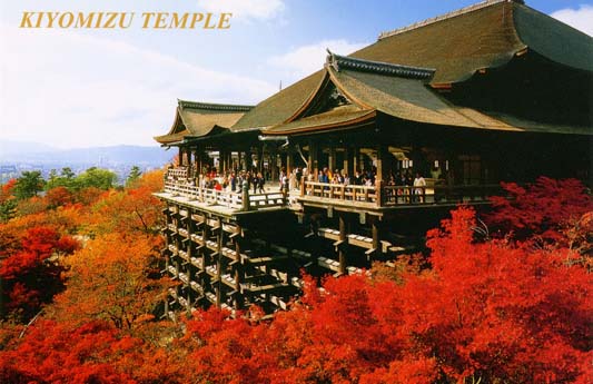
Making your way outside you come to the Butai (dancing stage). The stage is held up by wooden scaffolds that extends the stage 10 meters over a 12 meter cliff. This platform is one of the most photographed sites in Kyoto and immensely popular with Japanese. To the south you can see Koyasu-no-to (the easy child-birth pagoda), which contains an image of Koyasu Kannon. This view offers an excellent chance for a beautiful photograph, particularly in the autumn when the foliage is orange and red.
Up to the left is an unusual feature, the Shinto Jishu Shrine. The shrine is right in the middle of the temple, something that was not usual in Japan until the Meiji Restoration of 1868. After the Meiji Restoration, the government separated Shinto and Buddhism, often by destroying and/or physically relocating structures. Somehow the Jishu Shrine remained. Immensely popular with women, the god of love and good marriages resides in this shrine. It is worth the visit.
After you descend the stairs from Jishu Shrine, turn left and you will come to a line of buildings that lie beyond a large staircase. The first being Nishi-muki Jinzo, dedicated to the protector of the dead, travelers, and children. Next to Jinzo Shrine is Shaka-do which contains an image of the Buddha on a golden lotus flower. On one side of Shaka is an image of Monju (deity of wisdom) and on the other is Fugen (deity of virtue). Between Shaka-do and the next building, Amida-do, is a small structure containing 180 small images of Jizo. According to folklore if you come to pray at Hyakutai Jizo and see the face of your deceased child you can be sure that your child is at peace. The Amida-do has the traditional tiled roof of Buddhist temples and houses the image of Amida Nyorai (Buddha of the Western Paradise) with its hands in the traditional contemplation position. On May 15, 1188 Honen preached the doctrine of the Nenbutsu (Praise to the Buddha Amida) and thereby founded the cult of Amida and formed the Jodo sect of Buddhism. Five times per year a special Nenbutsu service takes place at Amida-do.
The final building is Okuno-in (Inner Temple). This site said to be the original home of the hermit Gyoei and the original crude structure that held Enchin's carvings of Kannon, Jizo, and Bishamon-ten. This location was also where Tomuramaro's sanctuary stood while it held the three images. This temple is dedicated to those images, even though they are now housed in the Hon-do. Beyond Okuno-in is the Nurete Kannon (Water-soaked Kannon); an image of Kannon in a water basin. To pour water over the image is considered an act of purification.
Below you will see people reaching out to Otowa-no-taki (Sound of Feathers Waterfall) with long wooden poles to fill cups with the "Clear Water" from the falls. On busy Sunday afternoons, there will be a long queue. At times you will also happen across people who stand beneath the falls praying to Fudo Myoo (God King of Fire who punishes evil-doers). The water is also said to have the power to prevent illness, so grab a cup and have a nice long drink.
In the north of the temple grounds is the Kita So-mon (North Gate) which leads to the main sub-temple of Joju-in. This temple was originally a private temple for the emperor Go-Kashiwabara (reign 1500-1526). From November 1st to November 10th the garden of the temple superior is open to the public. The creators of the garden, Soami (1455-1525) and Kobori Enshu (1579-1647) are two of Japan's most famous landscape gardeners. Viewed from the study of Joju-in the garden appears much larger than it acutally is. This is achieved by "borrowing scenery" from the nearby hills making it appear as part of the garden. The garden contains a pond with a large stone resembling the formal hat of the Heian period (eboshi) and two islands. The water basin, donated by Toyotomi Hideyoshi in the 1590's, is called Furisode (sleeve basin), so named because the stone's shape is similar to the long sleeves of a girl's kimono.
Heading back to the entrance of the temple from Joju-in you will come to Dai-kodo (Great Lecture Hall). Built in 1978 to commemerate the 1200th aniversary of the founding of the temple, this building has a central chamber called Taho-kaku (Tower of Many Treasures) and two wings. Within the Taho-kaku are the Bussoku-seki (Buddha's Footprints Stone) measuring four meters long. The four walls surrounding the footprints have 4076 images of the four Buddhas. To the north are images of Taho-Nyorai, to the south Shaka-Nyorai, the east Yakushi-Nyorai, and the west wall shows the images of Amida-Nyorai. The upper chamber of the tower enshrines some of the ashes of the historic Buddha.

Kiyomizudera is situated on approximately 130,000 square meters and consists of over 30 structures.

Admission Times / Hours Open: 6:00 - 18:00 (some parts close around 4)
Time Needed for Tour: About 40 minutes (at least)
Days Closed / Facilities Closed: Open daily

Cost of Admission: Main facilities (Main Hall, Balcony) 300 Yen

Address : 294 1-chome, Kiyomizu, Higashiyama-ku
Tel : 075-551-1234 Fax : 075-551-1287

How to get to Kiyomizudera?

1: From Kyoto Station:
Take bus 202, 206, or 207 and get off at Kiyomizu-michi or Gojo-zaka. From there make your way up hill past the shops and once you reach the top you will be in front of the temple.

2: From Okazaki:
Take the Kaisoku (Express) from JR Okazaki Station to JR Mikawa Anjo (10 minutes) or JR Nagoya Station (28 minutes). Change to a west bound Kodama shinkansen. Take bus 202, 206, or 207 and get off at Kiyomizu-michi or Gojo-zaka. From there make your way up hill past the shops and once you reach the top you will be in front of the temple. As of writing, the tickets cost XXXX yen one way and the journey takes about XXXX minutes not including the train change.

Thursday, December 25, 2008

Kilimanjaro, Africa


Mount Kilimanjaro rises majestically from a rolling plain close to the Indian Ocean from hot savanna to a barren and frigid 3-1/2 mile high peak. It's the highest mountain in Africa and one of the largest free standing mountains in the world. Climbing Kilimanjaro is a must-do challenge for almost every trekker and mountaineer in the world.
Kilimanjaro National Park takes in the area above the 8,850 feet, or 2,700 meters, on the mountain. It includes the moorland and highland zones, Shira Plateau, Kibo and Mawenzi peaks. In addition, the Park has six corridors or rights of way through the Kilimanjaro Forest Reserve. The Forest Reserve, which is also a Game Reserve, was established in 1921; the Park was established in 1973 and officially opened in 1977.

Kilimanjaro is a giant stratovolcano reaching an elevation of 19,335.6 ft. (5,895 m). Other names for this volcano are: Kilima Dscharo, Oldoinyo Oibor (white mountain in Masai), and Kilima Njaro meaning shining mountain in Swahili. This volcano's highest and youngest cone is named Kibo. Shira to the west and Mawenzi in the east are older cones that make up Kilimanjaro. Kibo has not been active in modern times, but steam and sulfur are still emitted. At the top of Kibo's summit is a 1 1/2 mile (2 1/4 Km) wide crater.
Kilimanjaro is the largest of an E-W belt of about 20 volcanoes near the southern end of the East African Rift Valley. Also prominent in this belt are Ngorongoro caldera - a superb wildlife refuge, Ol Donyo Lengi - a carbonitite volcano, and Meru. Kilimanjaro is a triple volcano with the youngest and central peak of Kibo being 7.5-8.7 miles (12-14 km) from Shira to the west and Mawenza to the east. As all of Kilimanjaro's climbers know the gentle lower slopes steepen to 30 degrees about 13,000 ft.(4 km) elevation.
Shira is topped by a broad plateau, perhaps a filled caldera, and erosion has cut deeply into a remnant rim. In contrast, Mawenzi's summit is a steep rocky peak surrounded by cliffs 1,600 ft.(0.5 km) to 4,900 ft.(1.5 km) high. Erosion has removed the original crater, and a great horseshoe shaped ridge opens to the northeast. Mile-deep gullies with 30-45 degree gradients make many places practically inaccessible. Massive series of radial and concentric dyke swarm make up more than 30-40 percent of the summit area of Mawenzi. Kibo's glacier-clad summit, the highest spot in Africa, is a 1.2 x 1.7 mile (1.9 x 2.7 km) caldera, with an inner crater nearly a mile (1.3 km) wide, and inside that a deep, 1,148 ft. (350 m) wide central pit. Original volcanic forms are preserved at the summit and on many of the flanks, except on the south side where glaciers have cut deeply into the cone. Nearly 250 satellitic cones occur on Kilimanjaro, most following SE and NW trends. Estimates suggest that of a total volume of about 1,150 cu. miles, Mawenzi and Shira each contribute roughly 120 cu. mi. of andesites and basalts, Kibo has the same volume of similar but unexposed rocks, plus an additional 107 cu. miles. Interestingly, more than half of Kilimanjaro's volume is represented by older, basal basalts (672 cu. mi.), so once again- as in Cascade stratovolcanoes - a basaltic shield is the most important, but least conspicuous element of a chemically complex volcano. Kilimanjaro- Africa's largest volcano and among the largest on the Earth is indeed a beautiful and fascinating volcano of the world.

Even though you can climb throughout the year, January, February and September are the best months, with July, August, November and December also being good.
Equatorial to arctic conditions are present on Kilimanjaro. The range begins with the warm, dry plains with average temperatures of 85°F, ascends through a wide belt of wet tropical forest, through zones with generally decreasing temperatures and rainfall, to the summit where there is permanent ice and below freezing temperatures.
The rainiest period is March to June. The fact that most months of the year have so few rainy days makes it possible to climb in relatively good conditions year round. During the rainy period of March to May, clouds tend to pile up and over the summit, dropping snow on top and rain at the base. Visibility can be limited by cloud cover even when no rain falls. The temperature at this time of year is relatively warm. The dry season, beginning in late June and through July can be very cold at night, but usually is clear of clouds. August and September are also cool and can have completely clear days, but usually a dripping cloud belt girdles the mountain above the forest and moorland. The summit can be totally clear and the successful climber looks down on a vast sea of clouds with distant mountain peaks poking through like islands.
The shorter rainy period of October to December often has thunderstorms that pass over the mountain, dropping rain as they go. Typically the clouds disappear in the evening, leaving nights and mornings clear with excellent visibility. January and February are usually dry, warm and clear with brief rain showers which make for good climbing conditions.
Kilimanjaro towers above the Great Rift Valley, possible birthplace of humankind and the site of the Leakey's research in the Olduvai Gorge. This gives Kilimanjaro an awesome mystique. One can imagine the mountain towering above our ancestors, making an early, continual impression on the species. When you walk the mountain, you'll probably encounter some odd, purposeful arrangements of stone. Your guides will claim to not know what they mean. Perhaps they don't.
...on Kilimanjaro, some mysteries may never be answered...
source 1 2

Twitter Delicious Facebook Digg Stumbleupon Favorites More

 
Design by Free WordPress Themes | Bloggerized by Lasantha - Premium Blogger Themes | GreenGeeks Review