Saturday, June 13, 2009

Hell's Door - Darvaza,Turkmenistan


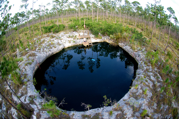
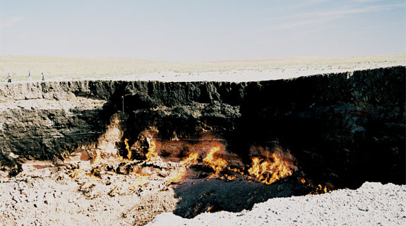
Located in the Kara-Kum desert of Turkmenistan is the village of Darvaza (Derweze) near to where, in 1971, a team of Soviet prospectors allegedly drilled into a large chamber filled with natural gas. The roof of the cavern collapsed leaving a crater-like sinkhole some 25 metres deep with a diameter of approximately 60 - 70 metres. It soon became evident that natural gas was still rising into the crater from even deeper sources and the story goes that the decision was made to ignite the emissions rather than risk either a concentrated build-up of gas or local poisoning. According to various sources it has burned continuously since then and has apparently been named “The Gate to Hell” by the local people. However, another source that spoke with the guides from the region claims that it is a wholly natural phenomenon.
This “it” is nearby the village of Darwaza (also spelled Derweze) in the middle of Turkmenistan’s Kara-Kum Desert. In 1971, when Turkmenistan was a republic of the Soviet Union, the state energy company was drilling near Darwaza when they accidentally bored into an underground cavern filled with natural gas. The drilling, combined with the sudden release of the pressure the natural gas was exerting on the cavern walls, caused the ground beneath the cavern to collapse.
Those working at the drill site were surprised (to say the least) to have suddenly collapsed the ground beneath them. Spot Cool Stuff, having no geologists on staff, is not in a position to judge whether the geologists at Darwaza in 1971 should have known the cavern was there. But what they did after the collapse seems to us to be . . . what’s the phrase? . . . incredibly stupid. The geologists decided to clear the cavern of the natural gas by setting it on fire.
It has been burning since.
The spectacle of this large burning gap in the ground is a rather incredible to witness. Obviously, it is most incredible at night when the red glow of the flames from Hell’s Gate are visible from up to 40 km (25 miles) away. The cater itself is about 75 meters (250 feet) at its widest point. The intense heat of the fire makes it difficult to stand near the carter’s edge for more than two or three minutes at a time. This is probably for the best: The funes coming from the crater are toxic.
Getting there: Darwaza is a bumpy four hour car ride from the Turkmen capital of Ashgabat.
Where to stay: There’s no hotel in Darwaza. A travel specialists can arrange both a stay in a local yurt along with a night time Hell’s Gate visit.

source 1 2

Monday, June 8, 2009

Blue Holes, Bahamas


The Great Blue Hole is located in the Light House Reef and lies 60 miles from the Island of Belize. In 1997 it was designated as a World Heritage site.

Found on both land and in the ocean throughout the Bahamas are deep circular cavities known as Blue Holes which are often the entrances to cave networks, some of them up to 14 kilometres in length. Divers have reported a vast number of aquatic creatures some of which are still new to science. In addition, they’ve recorded chambers filled with stalactites and stalagmites which only form in dry caves. For the explorers this was proof that at one time, nearly 65,000 years ago, when the world was in the grip of the last major ice age, the sea level of the Bahamas was up to 150 metres lower than it is today. Over time the limestone of the islands was eroded by water and vast cave networks created. When sea levels rose again about 10,000 years ago some of these collapsed inwards land the Blue Holes were formed...

Walls and blue holes are simultaneously special, and widespread, dive experiences in The Bahamas. Walls, the most generally dramatic expression of the coral reef, will at times plummet directly into the great trenches, thousands of feet deep, that line the archipelago. Blue holes, while not exclusively a phenomenon of The Bahamas, are found here in a greater number than anywhere on earth. And, The Bahamas has the only known tidal blue holes in the world. Together, the walls and blue holes turn The Bahamas dive experience on its side. Blue holes are a phenomenon created during several ice ages, when sea levels were 400 feet lower and The Bahamas was a great exposed limestone platform. Centuries of acidic rain water etched into the vast bank, creating circular depressions and other magnificent formations. Today, most blue holes are located in shallow water on the Great and Little Bahama Banks, while others are inland pools.

Wall Diving in The Bahamas

Walls are found throughout The Bahamas and their profiles range from those that end at sand bottoms 60 to 100 feet deep, to seemingly infinite vertical descents. It is along these escarpments of the deep reef that the majesty of coral spires and the magnificence of sponges is fully realized. Seafans, bryozoans, seawhips and Black Coral mix and mingle with the sponges, creating a garden carpet of life. More color and the addition of motion is provided from solitary and schooling reef fish. Every wall is similar, yet different: Profile, shape, size and predominant colors vary from site to site. The following walls are among the most stunning, popular and accessible in The Bahamas:
  • The Great Lucaya or Grand Bahama Wall
The southern coast of Grand Bahama Island is lined with a continuous fringing reef and drop-off with hundreds of wall sites featuring caves, caverns and swim-throughs. The top of the wall usually begins in about 80 feet of water.
  • Lyford Cay Wall
Off the northwest coast of New Providence Island (Nassau) is a famed coral cliff beginning in 35 feet of water.
  • Southwest Wall
Facing the Tongue of the Ocean on the New Providence side is a coral canyon several miles in length. The area adjacent to the popular shark dive sites is particularly colorful, with many sponge decorated pinnacles protruding from the wall.
  • The Andros Wall
The “greatest of all Bahama walls” is found at Andros, the largest island in the chain. The Andros Wall offers uncountable sites that display mountains and canyons of every shape and size.
  • The Bimini Wall
From the Biminis southward is a nearly continuous wall facing the Gulf Stream. The North Bimini Wall is just south of the entrance channel to North Bimini and begins in 120 feet of water. This is generally a drift dive for very experienced divers. To the south are numerous walls, such as those at South Cat Cay Wall, Victory Cays Drop-off and Riding Rock Wall—all of these are fish filled spectacles that begin in 30 to 90 feet.
  • The Exuma Wall
Directly off Highbourne Cay is a drop-off that faces the Exuma Sound. This is a vertical wall, 75 feet deep.
  • Chub Cay Wall
A continuous drop-off runs from the southwest tip of Chub Cay to Whale Cay, in the Berry Islands. These sites offer a variety of wall formations.
  • Riding Rock Wall
Dozens of popular wall sites are located along the western coast to the southern tip of San Salvador Island in the south-central Bahamas.
  • Conception Island Wall
Here is one of the most dramatic and colorful walls in all of the archipelago. The wall begins in 45 to 60 feet of water, its entire length decorated with spectacular sponge and coral formations.
  • Diving the Blue Holes
Blue holes that are accessible to divers are sprinkled throughout The Bahamas. Some are cavern diving experiences and others are mile-long labyrinths, off limits to sport divers. Access to blue hole diving varies; some are controlled and monitored by the Bahamas National Trust. Entry to others is policed by local organizations. Although some unique organisms are found in blue holes, the attraction here is chiefly geological—experiencing a spectacular visual realm seldom seen by other human beings. The greatest concentration of blue holes is found both inland and in the shallows of Andros Island, where more than 50 blue holes have been recorded. Other concentrations of blue holes occur on and off Grand Bahama Island (Ben’s Cavern, for example), the Exumas and Eleuthera. One of the world’s deepest blue holes is located off Long Island and is surrounded on three sides by land. A few well-known blue holes are located off Nassau, the Biminis and scattered throughout the Out Islands.
source 1 2

Sunday, June 7, 2009

Las Cañadas, Tenerife


We wonder how many of those sex and surf tourists look at the mountain that overshadows popular party places like Playas Las Americas and ever wonder – “Will it be today?” Las Cañadas caldera, Mount Teide – Not dead just sleeping!

Las Cañadas caldera, located at the central part of Tenerife, Canary Islands, is a large volcanic depression (16 x 9 km). The caldera is opened to the sea at the north side and filled by continuous layers of lava flows and fall deposits. These volcanic deposits form a good hydrogeological trap which is the largest ground water reserve of the island. In comparison, the basement of the caldera has low permeability. Numerous galleries (horizontal drains) intercept the Las Cañadas aquifer. During the last century, this aquifer has been overexploited depleting the water table as well as the water quality. The Teide-Pico Viejo volcanic complex is located at the margin of the caldera. The ascent of deep magmatic gases (e.g. CO2) confers aggressiveness to the waters causing rock dissolution and alteration. The aim of this work is to study water-rock interactions in Las Cañadas aquifer. Chemical diagrams showing the relative composition of Mg, Ca, Na and K as described by Giggenbach (1988) indicate that the waters discharged by the galleries correspond to the process of rock dissolution and evolution towards full rock-fluid equilibrium. The lower contents in Ca and Mg are found in the galleries which reach more deeply the north flank of the Teide Volcano, suggesting mineral precipitation and heating in this zone. Geochemical modeling of fluid-rock interactions using Chiller (Reed and Spycher, 1984) show that the gases discharged at Teide summit cannot generate the water compositions observed at Las Cañadas. These gases represent the separated phase of a condensation process within the volcanic edifice. Modeling of the gas-enriched Las Cañadas waters from the recharge zone with phonolitic rocks from the caldera show that the galleries waters correspond to the dissolution of 1 to 7 g of rock/liter of water and a relatively shallow circulation. The simulations suggest that waters have not encountered the ˜ 250° C temperature region suggested by the gas geothermometers. This behavior suggests that the heat source in this system is deep as suggested by geophysical studies.

At the summit of Mount Teide, one of the largest Island volcanoes in the World is the Las Cañadas caldera. The crater, which is an enourmous sixteen kilometres across, is a picture of what Hell might look like if it cooled a little. Shear walls that formed when the caldera first collapsed encircle this dry and alien place. And, with an arrogance than can only be accepted as typical, humanity has built roads and observatories across this no mans land that is little more than a plug over a sleeping yet still active and very large volcano. When we visited it some years ago we were standing in the viewing gallery when the ground beneath our feet trembled and several windows suddenly cracked. The sleeping giant was grumbling in its sleep. The land mass created by the volcano is Tenerife in the Canary Islands.source 1 2

Twitter Delicious Facebook Digg Stumbleupon Favorites More

 
Design by Free WordPress Themes | Bloggerized by Lasantha - Premium Blogger Themes | GreenGeeks Review