Saturday, May 30, 2009

Pamukkale - Turkey


The strange and weirdly beautiful terraced pools of Pamukkale (Pummakale) have been appreciated for over two millennia and yet still remain a little known wonder of the world. Thousands of years ago earthquakes, which are common in Turkey, created fractures that allowed powerful hot springs to bring water rich in calcium carbonate to the surface. As the water evaporated the chalky material condensed and formed layer-upon-layer of Travertine and thus slowly built up the walls over time in the same way that a stalactite forms in a cave. Apparently Pamukkale means Castle of Cotton but the Greco-Romans built a town above it called Heirapolis – meaning “Holy City” or “Sacred City”. They too recognised it as a rare and important place attributing healing powers to the milky-white waters.The travertine features have their origins in the shifting of a fault in the valley of the Menderes river (between here and Denizli). As the fault shifted, very hot springs with a very high mineral content (notably chalk) arose at this location.


source 1 2

Thursday, May 28, 2009

The Colossus of Rhodes


From its building to its destruction lies a time span of merely 56 years. Yet the colossus earned a place in the famous list of Wonders. "But even lying on the ground, it is a marvel", said Pliny the Elder. The Colossus of Rhodes was not only a gigantic statue. It was rather a symbol of unity of the people who inhabited that beautiful Mediterranean island -- Rhodes.
Location
At the entrance of the harbor of the Mediterranean island of Rhodes in Greece.
History
Throughout most of its history, ancient Greece was comprised of city-states which had limited power beyond their boundary. On the small island of Rhodes were three of these: Ialysos, Kamiros, and Lindos. In 408 BC, the cities united to form one territory, with a unified capital, Rhodes. The city thrived commercially and had strong economic ties with their main ally, Ptolemy I Soter of Egypt. In 305 BC, the Antigonids of Macedonia who were also rivals of the Ptolemies, besieged Rhodes in an attempt to break the Rhodo-Egyptian alliance. They could never penetrate the city. When a peace agreement was reached in 304 BC, the Antagonids lifted the siege, leaving a wealth of military equipment behind. To celebrate their unity, the Rhodians sold the equipment and used the money to erect an enormous statue of their sun god, Helios.
The construction of the Colossus took 12 years and was finished in 282 BC. For years, the statue stood at the harbor entrance, until a strong earthquake hit Rhodes about 226 BC. The city was badly damaged, and the Colossus was broken at its weakest point -- the knee. The Rhodians received an immediate offer from Ptolemy III Eurgetes of Egypt to cover all restoration costs for the toppled monument. However, an oracle was consulted and forbade the re-erection. Ptolemy's offer was declined.
For almost a millennium, the statue laid broken in ruins. In AD 654, the Arabs invaded Rhodes. They disassembled the remains of the broken Colossus and sold them to a Jew from Syria. It is said that the fragments had to be transported to Syria on the backs of 900 camels.
Description
Let us first clear a misconception about the appearance of the Colossus. It has long been believed that the Colossus stood in front of the Mandraki harbor, one of many in the city of Rhodes, straddling its entrance. Given the height of the statue and the width of the harbor mouth, this picture is rather impossible than improbable. Moreover, the fallen Colossus would have blocked the harbor entrance. Recent studies suggest that it was erected either on the eastern promontory of the Mandraki harbor, or even further inland. Anyway, it did never straddle the harbor entrance.
The project was commissioned by the Rhodian sculptor Chares of Lindos. To build the statue, his workers cast the outer bronze skin parts. The base was made of white marble, and the feet and ankle of the statue were first fixed. The structure was gradually erected as the bronze form was fortified with an iron and stone framework. To reach the higher parts, an earth ramp was built around the statue and was later removed. When the colossus was finished, it stood about 33 m (110 ft) high. And when it fell, "few people can make their arms meet round the thumb", wrote Pliny.
Although we do not know the true shape and appearance of the Colossus, modern reconstructions with the statue standing upright are more accurate than older drawings. Although it disappeared from existence, the ancient World Wonder inspired modern artists such as French sculptor Auguste Bartholdi best known by his famous work: The Statue of Liberty.

Wednesday, May 27, 2009

The Mausoleum at Halicarnassus


Similar to the Great Pyramid, we are now visiting the burial place of an ancient king. Yet the Mausoleum is different - so different from the Pyramid that it earned its reputation - and a spot within the list - for other reasons. Geographically, it is closer to the Temple of Artemis... And it was the beauty of the tomb rather than its size that fascinated its visitors for years.
  • Location
In the city of Bodrum (f.k.a. Halicarnassus) on the Aegean Sea, in south-west Turkey.
  • History
When the Persians expanded their ancient kingdom to include Mesopotamia, Northern India, Syria, Egypt, and Asia Minor, the king could not control his vast empire without the help of local governors or rulers -- the Satraps. Like many other provinces, the kingdom of Caria in the western part of Asia Minor (Turkey) was so far from the Persian capital that it was practically autonomous. From 377 to 353 BC, king Mausollos of Caria reigned and moved his capital to Halicarnassus. Nothing is exciting about Maussollos life except the construction of his tomb. The project was conceived by his wife and sister Artemisia, and the construction might have started during the king's lifetime. The Mausoleum was completed around 350 BC, three years after Maussollos death, and one year after Artemisia's.
For 16 centuries, the Mausoleum remained in good condition until an earthquake caused some damage to the roof and colonnade. In the early fifteenth century, the Knights of St John of Malta invaded the region and built a massive crusader castle. When they decided to fortify it in 1494, they used the stones of the Mausoleum. By 1522, almost every block of the Mausoleum had been disassembled and used for construction.
Today, the massive castle still stands in Bodrum, and the polished stone and marble blocks of the Mausoleum can be spotted within the walls of the structure. Some of the sculptures survived and are today on display at the British Museum in London. These include fragment of statues and many slabs of the frieze showing the battle between the Greeks and the Amazons. At the site of the Mausoleum itself, only the foundation remains of the once magnificent Wonder.
  • Description
The structure was rectangular in plan, with base dimensions of about 40 m (120 ft) by 30 m (100 ft). Overlying the foundation was a stepped podium which sides were decorated with statues. The burial chamber and the sarcophagus of white alabaster decorated with gold were located on the podium and surrounded by Ionic columns. The colonnade supported a pyramid roof which was in turn decorated with statues. A statue of a chariot pulled by four horses adorned the top of the tomb.
The total height of the Mausoleum was 45 m (140 ft). This is broken down into 20 m (60 ft) for the stepped podium, 12 m (38 ft) for the colonnade, 7 m (22 ft) for the pyramid, and 6 m (20 ft) for the chariot statue at the top.
The beauty of the Mausoleum is not only in the structure itself, but in the decorations and statues that adorned the outside at different levels on the podium and the roof. These were tens of life-size as well as under and over life-size free-standing statues of people, lions, horses, and other animals. The statues were carved by four Greek sculptors: Bryaxis, Leochares, Scopas, and Timotheus, each responsible for one side. Because the statues were of people and animals, the Mausoleum holds a special place in histroy as it was not dedicated to the gods of Ancient Greece.
Since the nineteenth century, archeological excavations have been undertaken at the Mausoleum site. These excavations together with detailed descriptions by ancient historians give us a fairly good idea about the shape and appearance of the Mausoleum. A modern reconstruction of the shorter side of the Mausoleum illustrates the lavish nature of the art and architecture of the building... a building for a King whose name is celebrated in all large tombs today -- mausoleums.


Tuesday, May 26, 2009

Mururoa


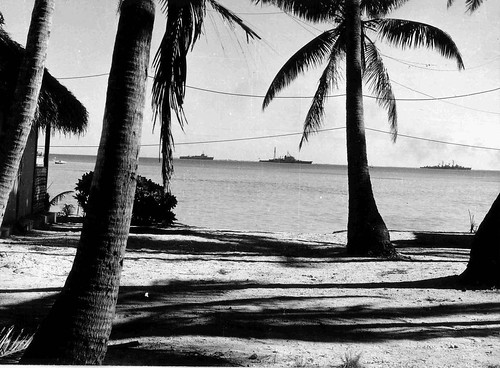
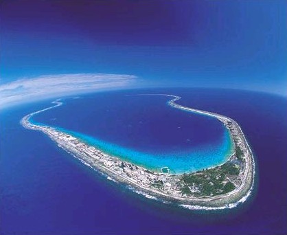
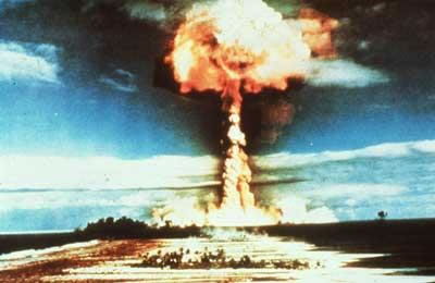
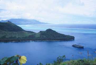
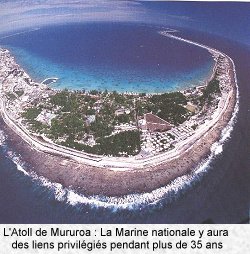
The French Polynesian atolls, of Mururoa [21°52'S 138°55'W] and Fangataufa [22°14'S 138°45'W] (atolls of the Tuamutu) in the South are known as the Pacific Test Center. These sites were chosen by the French state for the different types of testing because of their relative isolation and geological characteristics. From the geographical point of view, Mururoa, the largest of the two atolls, with a perimeter of 60 kilometers, was 40 kilometers away from Fangataufa. These two Polynesian territories are part of France, although they are some 20 000 kilometres away from the metropolis. The test sites were created on 21st September 1962 and the Direction des Centres d'Experimentation Nucleaires (DIRCEN) was made responsible for organising and exploiting firings. Hao, 450 kilometres north-west of Mururoa, was chosen as advanced support base. Considerable modernisation work was carried out there for this purpose.

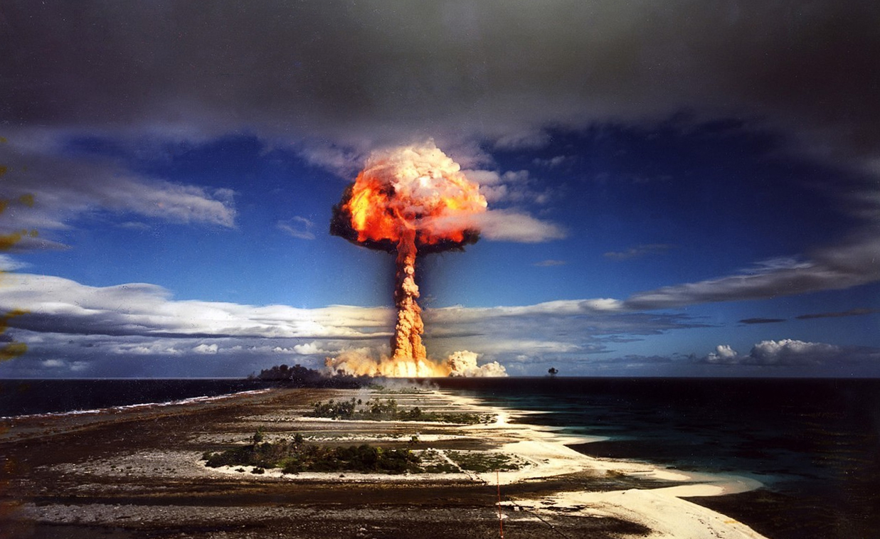
The first tests conducted at the Mururoa and Fangataufa sites were atmospheric. After 41 tests in the atmosphere, underground tests were started in June 1975. In all, 41 tests in the atmosphere and 134 tests in boreholes in the atolls (from the edge of the atolls or in the central zone) were conducted between 1960 and 1991 on Mururoa and Fangataufa. Added to those in the Sahara, France had thus conducted a total of 192 tests up to 1992.

On 8th April 1992, President Francois Mitterrand, through his Prime Minister, announced the suspension of French nuclear tests that year. Thus started the French moratorium on nuclear tests which was renewed several times, finally to be suspended by the new French President, Jacques Chirac, in 1995. On 13th June 1995, as President of the French Republic, Mr. Chirac announced the resumption of nuclear tests by France; this was to be a final series of eight tests between September 1995 and May 1996. The French President announced simultaneously that France would carry out a final campaign of nuclear testing in the Pacific and that it would sign a universal and verifiable Comprehensive Nuclear Test Ban Treaty (CTBT). The last French nuclear test took place on January 27, 1996.

In March 1996, France signed the protocols of the Rarotonga Treaty, establishing a nuclear-free zone in the South Pacific. By adhering to the Rarotonga Treaty, France definitively gave up using the CEP for its intended mission.

France did not await the signing of the CTBT to begin dismantling facilities specifically linked to nuclear experimentation. Substitute activities --both civilian and military--were sought. None were found to be viable, essentially because of the prohibitive cost of operations at the atolls due to their distance from Tahiti, their isolation in the middle of the Pacific and the absence of natural resources (fresh water in particular). It was therefore decided to return the atolls to their intitial wild state. Prior to the creation of the EP, Mururoa and Fangataufa were indeed completely uninhabited. Leaving equipment or buildings in place without a specific use would have been incompatible with properly ensuring the safety of the people on the sites. Indeed, the climatic conditions and salt air quickly lead to the deterioration of anything that is not maintained.

Following aerial experiments, the necessary restoration and decontamination work was carried out, placing all above-water sections of the atolls in compliance with public access standards. Access restrictions that may remain in place in certain areas are due solely to the dangers posed by possible poor weather conditions. After the end of underground tests, well heads were plugged, guaranteeing that the products of nuclear explosions would remain totally contained over the long-term. No restoration or decontamination was necessary following this type of test.

Depending on their nature, the materials and equipment used at the CEP met with different fates. At the CEP, the Atomic Energy Commission used equipment that was specific to the performance of tests. Barges and drilling equipment were sold to private companies after being checked for radiation; these will be used for prospecting in Australia. Measuring equipment, consisting of various instruments and computer systems, were returned to France. As for surveillance equipment, it wil be kept on site for use in long-term geological and radiological surveys. Military equipment rendered useless (ships, helicopters) was returned to the army, which was in charge of operating it for the CEP. All other conventional materials and equipment were evaluated according to how well they were preserved and how well they satisfied standards of use. Whatever was in need of repair or did not meet security standards or the standards of use defined by labor legislation was destroyed at the site.

Facilities that still satisfy a need may be reused, particularly in Hao; this is the case, for example with the freshwater production system. Indeed, the State has decided to maintain and even to strengthen its presence in Hao with the assignment there of the 5th Foreign Regiment, which will continue to carry out important work for Polynesia (landing strips, roads, etc.) Other facilities and equipment that have little residual value given the cost of transport and reassembly at a different site will be destroyed.

Very low-activity wastes consist of such items as tools used for boring to determine radiochemical measurements after nuclear tests. They are processed and placed in deep wells, comparable to those used for the tests. The waste is thus safely contained for the long term in a manner identical to that of residue from nuclear explosions.

The territorial deliberation of 1964 ceding the atolls of Mururoa and Fangataufa to France called for their return in the event of the cessation of activities by the CEP. However, the halt of nuclear tests does not mean the end of all activities on the sites in the immediate term, as surveillance of the atolls is necessary. Surveillance of the sites remains the responsibility of the defense forces, implying the presence of legionnaires and an ongoing military status for these atolls for the necessary duration.

Future geological surveillance of the atolls of Mururoa and Fangataufa will be carried out through an automated system (TELSITE) focusing essentially on Mururoa and involving periodic obeservation campaigns coupled with radiological surveillance campaigns. Ambient radioactivity in the air and water will also be monitored by an automated station. These continuous measures will be supplemented by annual campaigns which will take samples from the physical environment (air, soil, water, sediment) and the biological domain (plants, fish, plankton, shellfish). This surveillance program may be modified to take into account recommendations made by the international scientific mission under the aegis of the IAEA.

Twitter Delicious Facebook Digg Stumbleupon Favorites More

 
Design by Free WordPress Themes | Bloggerized by Lasantha - Premium Blogger Themes | GreenGeeks Review