7:30 PM
 crkota


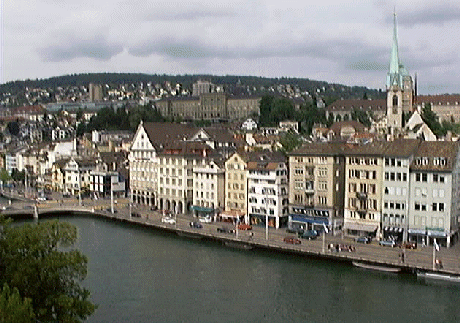
Situated on the shores of Lake Zurich, overlooked by the snowy peaks of the Alps, the city of Zurich is considered to be one of the most beautiful in Europe. Despite being the largest city in Switzerland, visitors will find Zurich has managed to maintain much of its old-world charm, while its compact size and convenient layout make it ideal for exploration on foot. As home to one of the world’s most extensive and efficient transport systems, less energetic visitors will also find the city equally easy to navigate.
The city’s long list of world-class museums and galleries provide a cultural experience to satisfy even the most ardent of art lovers, with the Kunsthaus Zurich and the Landesmuseum just two of the city’s exceptional offerings. Visiting families won’t be disappointed either, as the city provides plenty of activities to keep children entertained; the world renowned Dolder Zoo and the Lindt and Sprungli Chocolate Factory are two attractions children won’t want to miss.
Shopping and dining opportunities are superb, with the Bahnhofstrasse area of the old town seemingly bursting with high quality shops and boutiques. As well as being a shopper’s dream, Zurich also provides a culinary experience that rivals many of its European neighbours, particularly in the summer months, when the streets come alive with pavement cafés and restaurants.
History
Most cities have modest origins, and Zurich is no exception. The Roman garrison of Turicum stationed in the area in 15 BCE near the present-day Lindenhof, and in 370 CE, just 30 years after the Romans had left, a small fort sprang up on the same site. In the following centuries Alemannic and Frankish tribes settled in the area, marking the place where this great city would later flourish.
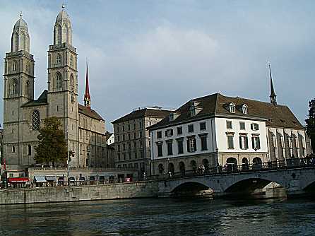
The foundation of the Fraumünster cathedral was laid down in 853 by Ludwig the German, a grandson of Charlemagne, and the first recorded mention of the city dates back to 929. In the following years, Otto the Great reunited Italy with Germany, thus reinforcing Zurich's important strategic position as a bridgehead between the two states. German emperors frequently came to the Lindenhof to discuss their policies in Italy. In 1098 the imperial province of Zurich came under the rule of the Zähringer dynasty. After that line died out in 1218, Zurich became a free city, albeit still part of the kingdom. Two years later the first city council came into being. After the founding of the Swiss Confederation in 1281 Zurich allied itself with the other cantons against the Habsburgs, who defeated them and lay siege to the city. In 1336 the knights and wealthy merchants lost their preeminent position in the city council as political rights were extended to poorer craftsmen and artisans, who organized themselves into powerful guilds. Zurich formally joined the Swiss Confederation in 1351, where it remained despite various conflicts and upheavals.
In 1519 Huldrych Zwingli, a central figure in the European Reformation, became a minister at the cathedral. Battles over iconoclasm raged and by 1525 the Reformation was complete. In 1648 Zurich was expelled from the German Empire. The old confederate system came to an abrupt end in 1798 with the onset of the Napoleonic wars and the advance of the French armies. The following year, Zurich became the fulcrum of the war and was variously besieged by French, Austrian and Russian forces. After the restoration of peace, Zurich blossomed and enjoyed an unprecedented economic boom. The University, to this day Switzerland's largest and most prestigious, was founded in 1833. Fourteen years later, the first railway line going through Zurich was constructed. With the conglomeration of 11 hitherto self-contained districts, the city's population swelled to 120,000. During both World War I and II Zurich was a haven for refugees fleeing authoritarian regimes. German author Thomas Mann lived here for a while, as did Albert Einstein and Lenin.
After the upheavals of 1968, Zurich saw further student protests, which reached a climax in the early 1980s. The city also earned notoriety for its harm-reduction approach to drug policy, its liberal party atmosphere, especially the Street Parade, and for its position as the center of offshore banking. Zurich, with its 360,000 inhabitants, undoubtedly sets the standard in banking and finance, service industries and culture. It is considered a "world city" and earned recognition in 2006 for having the best standard of living in the world.
Weather
Switzerland is generally portrayed as a cold and snow-swept country that receives little sun; however, this is far from the truth. In reality, Switzerland enjoys a mild climate due to the warm winds that blow in from the Atlantic Ocean.
Zurich’s mild climate means it is popular with visitors throughout the year, with the summer months of June to September being the busiest, as temperatures during these months average around 25°C, with little rain. The winter season begins around November and continues through to April, when the snows melt, although throughout the winter temperatures rarely drop far below 0°C in Zurich. Visitors to the Swiss mountains are continually surprised by the winter weather, with long days of warm sunshine and blue skies being far from unusual.


The city’s long list of world-class museums and galleries provide a cultural experience to satisfy even the most ardent of art lovers, with the Kunsthaus Zurich and the Landesmuseum just two of the city’s exceptional offerings. Visiting families won’t be disappointed either, as the city provides plenty of activities to keep children entertained; the world renowned Dolder Zoo and the Lindt and Sprungli Chocolate Factory are two attractions children won’t want to miss.
Shopping and dining opportunities are superb, with the Bahnhofstrasse area of the old town seemingly bursting with high quality shops and boutiques. As well as being a shopper’s dream, Zurich also provides a culinary experience that rivals many of its European neighbours, particularly in the summer months, when the streets come alive with pavement cafés and restaurants.
History
Most cities have modest origins, and Zurich is no exception. The Roman garrison of Turicum stationed in the area in 15 BCE near the present-day Lindenhof, and in 370 CE, just 30 years after the Romans had left, a small fort sprang up on the same site. In the following centuries Alemannic and Frankish tribes settled in the area, marking the place where this great city would later flourish.
The foundation of the Fraumünster cathedral was laid down in 853 by Ludwig the German, a grandson of Charlemagne, and the first recorded mention of the city dates back to 929. In the following years, Otto the Great reunited Italy with Germany, thus reinforcing Zurich's important strategic position as a bridgehead between the two states. German emperors frequently came to the Lindenhof to discuss their policies in Italy. In 1098 the imperial province of Zurich came under the rule of the Zähringer dynasty. After that line died out in 1218, Zurich became a free city, albeit still part of the kingdom. Two years later the first city council came into being. After the founding of the Swiss Confederation in 1281 Zurich allied itself with the other cantons against the Habsburgs, who defeated them and lay siege to the city. In 1336 the knights and wealthy merchants lost their preeminent position in the city council as political rights were extended to poorer craftsmen and artisans, who organized themselves into powerful guilds. Zurich formally joined the Swiss Confederation in 1351, where it remained despite various conflicts and upheavals.
In 1519 Huldrych Zwingli, a central figure in the European Reformation, became a minister at the cathedral. Battles over iconoclasm raged and by 1525 the Reformation was complete. In 1648 Zurich was expelled from the German Empire. The old confederate system came to an abrupt end in 1798 with the onset of the Napoleonic wars and the advance of the French armies. The following year, Zurich became the fulcrum of the war and was variously besieged by French, Austrian and Russian forces. After the restoration of peace, Zurich blossomed and enjoyed an unprecedented economic boom. The University, to this day Switzerland's largest and most prestigious, was founded in 1833. Fourteen years later, the first railway line going through Zurich was constructed. With the conglomeration of 11 hitherto self-contained districts, the city's population swelled to 120,000. During both World War I and II Zurich was a haven for refugees fleeing authoritarian regimes. German author Thomas Mann lived here for a while, as did Albert Einstein and Lenin.
After the upheavals of 1968, Zurich saw further student protests, which reached a climax in the early 1980s. The city also earned notoriety for its harm-reduction approach to drug policy, its liberal party atmosphere, especially the Street Parade, and for its position as the center of offshore banking. Zurich, with its 360,000 inhabitants, undoubtedly sets the standard in banking and finance, service industries and culture. It is considered a "world city" and earned recognition in 2006 for having the best standard of living in the world.
Weather
Switzerland is generally portrayed as a cold and snow-swept country that receives little sun; however, this is far from the truth. In reality, Switzerland enjoys a mild climate due to the warm winds that blow in from the Atlantic Ocean.
Zurich’s mild climate means it is popular with visitors throughout the year, with the summer months of June to September being the busiest, as temperatures during these months average around 25°C, with little rain. The winter season begins around November and continues through to April, when the snows melt, although throughout the winter temperatures rarely drop far below 0°C in Zurich. Visitors to the Swiss mountains are continually surprised by the winter weather, with long days of warm sunshine and blue skies being far from unusual.